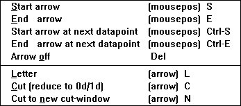
or the key "C"/"N" can be selected in order to calculate the cut and display it in an existing cut-window (if a cut window already exists) or in a new cut-window (forced by "N").
Once the arrow for the desired cut (section) is drawn, the appropriate
menuitem of the "Arrow" menu
or the key "C"/"N" can be selected in order to calculate the cut
and display it in an existing cut-window (if a cut window already exists) or
in a new cut-window (forced by "N").
As example this orange arrow
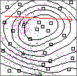
would lead to this cut-window:
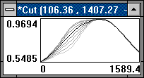
On the x-axis is the spatial coordinate in the direction
of the arrow; on the y-axis is the value-scale (for the by fuzzy kriging
interpolated value).
The actual display depends upon the cuts-section in the input-file:
The black curve in the center of the curves is the most possible value (the
value with membership 1.0), the outermost curves are these for membership
0.0 and the curves between for the rest of the level-cuts selected by the
cuts-section of the input data file.
(A fuzzy value can be seen at each column of pixels.)
More about display options at these pages: